Loch Lochy and Loch Eil
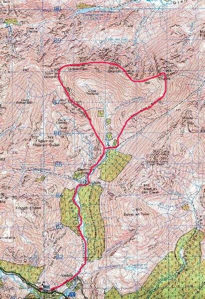
Sgurr nan Coireachan and Sgurr Thuilm lie just outside the Rough Bounds of Knoydart, peaks that I had completed a few weeks before. The views from the summit of both Munros are potentially great westwards towards Rhum and Skye.
A private road was taken up Glen Finnan and under the impressive Victorian concrete viaduct. The Corryhully bothy was passed and the track followed for another 1km to its highest point, passing a waterfall on the way. A small cairn and signpost showed the path to Sgurr nan Coireachan. Sgurr a'Choire Riabhaich summit was sidetracked slightly until at a minor top, a line of fence posts was picked up and followed to Sgurr nan Coireachan's summit.
From Sgurr nan Coireachan's summit a worn path and fence-
The descent was over mainly
grassy ground down Druim Coire a'Bheithe to the right of way in Glen Finnan, the
Corryhully bothy and finally back to Glen Finnan. A fine circuit.
|
Sron a’ Choire Ghairbh Meall na Teanga |
937m/3074m 918m/3012ft |
| |
|
date climbed |
27 June 2012 |
time taken |
6 hours |
|
distance |
13 miles |
ascent |
4200ft 1295m |
|
OS Map |
Landranger 33 |
Weather |
Limited visibility and strong winds |
|
Starting point : North end of Loch Lochy | |||
|
Gulvain |
987m/3238ft |
| |
|
date climbed |
Afternoon 26 June 2012 |
time taken |
7 hours |
|
distance |
12miles |
ascent |
3700ft 1130m |
|
OS Map |
Landranger 40 and 41 |
Weather |
Limited visibility and strong winds. Very heavy rain showers |
|
Starting point : Drumsallie GR 960794 | |||
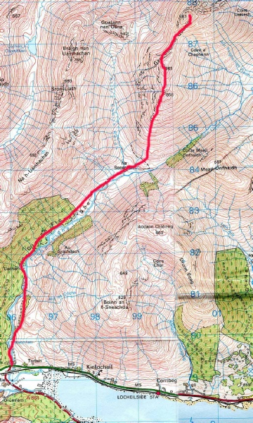
Gulvain is a long mountain standing above Loch Eil to the south and Loch Arkaig to the north. Access from the south was made by an easy track up Glen Fionnlighe.
After parking the car carefully so as not a annoy any of nearby houses, the track
was located complete with signpost, This initially climbs then flattens and drops
to a bridge over the Fionn Lighe. The Allt a'Choire Reidh was finally crossed using
the wooden bridge and the path started to zig-
|
Sgurr nan Coireachan Sgurr Thuilm |
956m/3136ft 963m/3159ft |
| |
|
date climbed |
Morning 26 June 2012 |
time taken |
6.5 hours |
|
distance |
12 miles |
ascent |
4000ft 1220m |
|
OS Map |
Landranger 40 |
Weather |
Fair with some broken mist on the top |
|
Starting point : Glenfinnan | |||
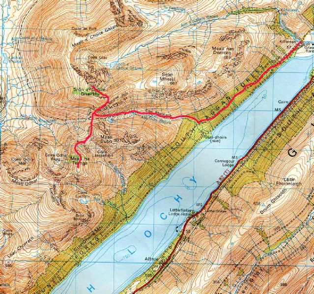
Sron a'Choire Ghairbh and Meall na Teanga can be seen as you drive along the A82
north of Spean Bridge, They stand above Loch Lochy and are accessed by Kilfinnan.
The forestry tracks were used to help make rapid and easy progress to these Munros
and fine stalkers paths continued to just below the summits.
As Steven Fallon suggested
in his route, the car was left at the turning circle by the farm at Kilfinnan without
any aggravation of any sort. The forestry track was followed until a sign-
After returning back down to the stalker's path at the bealach between the peaks, the climb up the slopes of Meall na Teanga was started. Thick mist on the peaks did not cause any signifiance navigational problems but it was difficult to gain any idea of the lie of the land from the top.